
Ancient Woodland
Bedford Purlieus - a National Nature Reserve
Ancient Woodland in Rockingham Forest
Updating the records - a call for volunteers
by Andy Lear
In 2023 Andy worked for the local Wildlife Trust updating the Ancient Woodland Inventory for Northants and Bedfordshire. Early in the year Andy wrote a call for volunteers to help with this work and he now describes progress so far.
An update on the update! (October 2023)
An Ancient Woodland site is defined (in England) as having been continuously wooded since 1600. Such sites have immense ecological and historical importance and are some of our most species-rich sites for wildlife. A provisional national inventory of ancient woodland sites was first compiled in the 1970s and 80s. With the advent of digital mapping the inventory is now being updated. This will enable woodland boundaries to be refined using map resources which were unavailable to the original compilers and incorporating more recent historical research. It will also allow small woods between 0.25 and 2 ha to be added to the inventory, as these were omitted from the original. Hopefully this will produce a more definitive inventory, although there will always be sites without conclusive evidence of their status, or whose status might change should new evidence be forthcoming.
We have now started on the final phase of the Northamptonshire Ancient Woodland Inventory update. Woods across the county were mapped and categorised as definitely ancient, potential ancient or secondary (not ancient) woodland. Over the spring and summer of 2023 about 250 of the potential ancient woods across the county were surveyed by volunteers and staff. The results have been used to help assess woodland status, to supplement historical documentary evidence particularly where this was lacking.
At least 350 hectares of extra Ancient Woodland now recognised in Northamptonshire
In Northamptonshire nearly 800, mainly smaller woods – many between 0.25 and 2 ha in size – were identified as potentially ancient. Other existing ancient woodlands have had their boundaries refined using maps and information not available to the compilers of the original inventory. The net result has been to add up to 800 ha of ancient woodland to the inventory. Some sites still need more information to verify their age and might be removed as part of the final revision process, but even if all these are removed there will still be an increase of about 350ha in the area of recognised ancient woodland in the county.
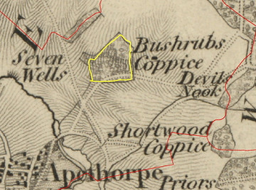
In the case of the Rockingham Forest, the overall distribution of ancient woodland remains much the same (see map below). However, a few sites have been added including parts of North Spinney (Fineshade Woods) and Bushshrubs (near Apethorpe). The latter was deleted from the original inventory because the extensive planting of non-native species made it look like a secondary wood. However historical maps and documents show that this has been woodland since the Middle Ages, and surveys revealed the presence of ancient-woodland indicator plants species growing within it. It has therefore been re-instated. (See maps and details of Bushrubs Wood below.)
Another category has been added to the inventory – Ancient Wood Pasture (AWP). Wood pasture is woodland kept open by the action of browsing animals and was a feature of parts of Rockingham Forest when it was a Royal Forest. In some instances, the cessation of grazing or in-fill tree planting has turned such areas to closed canopy woodland – and these are categorised as In-filled Wood Pasture. Although hard to differentiate from many C17 and C18 landscape parks, some areas of AWP have been identified within the Rockingham Forest. Examples include Deene Park and Fermyn Hall Deer Park. Some of the open areas of Hazel and Thoroughsale Woods in Corby have this character too.
Read more about the deer parks of Rockingham Forest here

Deene Park now identified as "Ancient Wood Pasture" - a new category for the inventory
Originally the project was due to end in September 2023, but The Woodland Trust and Natural England have agreed to fund a project extension through to June 2024, to allow more time to refine the inventory. In addition, we will also be updating the Ancient Woodland Inventory for Leicestershire and Rutland as Leicestershire and Rutland Wildlife Trust did not have the resources to take this on. Katharine Flach will be carrying on with Cambridgeshire and finalising the Bedfordshire and Northamptonshire Inventories whilst Andy Lear will be working on Leicestershire and Rutland.
We would like to thank everyone who helped with 2023's woodland surveys and hope that you enjoyed them. If you would like to take part again in 2024, we will be pleased to have help to survey specific woods throughout Bedfordshire, Cambridgeshire and Northamptonshire. This will be the final round of surveys for the project, and we will be concentrating on visiting poorly documented woodlands in the early spring. We will produce a new range of survey materials and send information about these to everyone who was involved last year. Do let us know if you are not able to take part again in spring 2024 and we will be happy to remove you from the volunteer list.
Volunteers needed to complete the inventory in the spring of 2024

Map data copyrighted OpenStreetMap contributors and available from https://www.openstreetmap.org
Ancient woodland in the Rockingham Forest
ASNW: Ancient Semi-natural Woodland;
PAWS: Plantation on an Ancient Woodland Site;
AWP: Ancient Wood Pasture;
IAWP: In-filled Ancient Wood Pasture
You can download a larger version of this map here.
What is “ancient” woodland?
Ancient Woodland is defined (in England) as a site which has been continuously wooded since 1600. It was once a dominant habitat but now only covers about 2.5% of the UK land area. The locations of these remaining fragments relate to settlement patterns, land use and ownership, and environmental constraints on farming and woodland clearance throughout history. The conditions created by centuries of undisturbed woodland growth and decay have created a rich and complex habitat. The species that have evolved to live in these environments are often slow to colonise, unable to survive in other conditions and are subsequently increasingly rare. It is therefore important to identify and protect the remaining ancient woodland for the future.
An area of woodland must have been ‘continuously wooded’ to classify as ancient. Ancient Woodland habitat is almost impossible to replicate due to its slow development but continuously wooded sites maintain ancient woodland characteristics such as soils, ground flora, fungi, and woodland archaeology. However, woodlands do not have to have been entirely tree-covered throughout the period. Open spaces, both temporary and permanent, are an important feature of woodland. These might occur as natural clearings and disturbance or due to tree felling and coppicing, which have been part of the use and management of woodland throughout much of history. Since it may have been partially cut many times in the past, an Ancient Woodland may not appear to have a high number of ancient or veteran trees. It can even be plantations of non-native species if this occurred without a period of non-wood cover. Such woodlands retain ancient woodland features and they can respond well to restoration management.

Ancient Woodland - this is publicly accessible land deep in Fineshade Wood
Why update the inventory?
The Ancient Woodland Inventory is an existing register compiled in the 1980s to provide a record of ancient woodlands over two hectares. Originally produced in the form of reports and paper maps on a county basis, these have since been digitised to create a national dataset. It is a valuable resource for conservation and planning but has some inaccuracies from the initial mapping and the digitisation process and subsequent woodland loss, especially when used at the local scale. While areas of the inventory have been intermittently updated, the widening gap between the standards of the data and its use in determining the outcome of development or woodland management proposals can create significant problems for the authorities involved.
Map showing currently recorded AW areas between Blatherwycke and Southwick.
You can view the complete Ancient Woodland Inventory using the interactive Natural England Open Data Geoportal here

The aim of the update is to standardise and update the data held by the Ancient Woodland Inventory across the country. Since its creation, the availability of evidence, understanding of ancient woodland, and potential mapping detail have increased considerably. The update will include a revision of the current inventory to ensure that known ancient woodlands are still present, correctly mapped, and supported by additional historical evidence accessed. Previously undesignated ancient woodland will be added to the inventory. These may be sites or parts or larger woodlands which were missed due to mapping inaccuracies or availability of evidence, but are predominantly the addition of smaller woodlands down to 0.25 hectares. The Ancient Woodland Inventory update has also been expanded to include Wood-Pasture and Parkland. Wood-Pasture and Parkland is grazing land with scattered scrub and trees which are often traditionally managed through pollarding. Where ancient wood-pasture is identified, it should receive the same consideration as other forms of ancient woodland but the low tree density of this habitat means that they were not recorded as woodland on the current inventory.
How the update is being done
The initial stages of the Ancient Woodland Inventory update process involved using modern aerial photographs, MasterMap, and 1st Edition Ordnance Survey maps (Epoch 1, published 1843-1893) to identify areas shown as woodland in both the late 1800s and the present day. These are considered to be ‘Long-Established Woodland’. The results from this were compared with the existing Inventory to identify areas that may be additions to the inventory and to check the previously designated areas. This process has been undertaken by the Local Environmental Records Centres within Bedfordshire, Cambridgeshire, and Northamptonshire.
Maps showing Bushrubs Wood near Apethorpe.
-
Current aerial image,
-
1824 OS 1st series maps
-
Ordnance Survey Drawings
It was not currently included in the Ancient Woodland Inventory.
(Google Imagery c 2022, Getmapping plc, Infoterra Ltd & Bluesky/Copernicus/Maxar Technologies, The GeoInformation Group, Map Data c2022)
The current task is to track each area identified as Long-Established Woodland through time to establish its ‘ancient’ status. We have been locating, accessing, and geo-referencing historical maps (OS drawings, tithe maps, estate maps etc.) to trace each area back in time towards the 1600s. We are also using more recent maps and photographs to ensure that the areas were not cleared and replanted at a later date. While some larger areas of woodland are easy to track through history, new additions to the inventory are likely to be smaller areas (since the original inventory only went down to two hectares and the update to 0.25 hectares) and those with a sparser historical record. The accumulation of evidence from multiple sources will therefore enable us to have the best knowledge of a woodland’s continued presence since 1600 and produce an accurate map of this rare habitat across the three counties, to support its better management, protection, and understanding.
Getting involved


Woodland surveys were prepared which would provide evidence for, or against, each area’s inclusion in the updated Ancient Woodland Inventory. Woodland often has physical indications of age, such as coppiced trees, banks and ditches to mark boundaries or signs of buildings and settlements in more recently established woodland. The species found within a woodland can also provide additional evidence. Certain species naturally occur near-uniquely in older woodland and colonise new areas slowly, therefore the presence of multiple of these indicator species suggests that an area of woodland is more likely to be ancient. We undertook the surveys of the potential Ancient Woodland sites in the spring with hundreds of sites to investigate.
The survey asked volunteers to visit woods we have identified which are potentially new additions to the AW register and which have public access or are visible from public rights of way. They then recorded ancient woodland features, including indicator species of plants such as bluebells etc.
If you would be interested in undertaking some basic woodland surveys in your local area , please register your interest by emailing Katharine.Flach@wildlifebcn.org
Banhaw Wood near Lower Benefield. Private Woodland with a public footpath - Currently ON the inventory.

Bushrubs Wood near Apethorpe. Private Woodland with a public footpath. It was not previously on the inventory but will be in the future